> ## Documentation Index
> Fetch the complete documentation index at: https://cockroachlabs.mintlify.site/llms.txt
> Use this file to discover all available pages before exploring further.
# GeoJSON
export const InternalLink = ({version, path = "", children, ...props}) => {
let detectedVersion = version || "stable";
if (typeof window !== 'undefined' && !version) {
const match = window.location.pathname.match(/\/docs\/([^/]+)/);
if (match) {
detectedVersion = match[1];
}
}
const normalizedPath = path.startsWith("/") ? path.slice(1) : path;
return
{children}
;
};
GeoJSON is a textual data format for representing spatial information. It is based on [JavaScript Object Notation (JSON)](https://www.json.org/).
GeoJSON can be used to represent the following spatial objects, which also have Well Known Text (WKT) and Well Known Binary (WKB) representations:
* Point
* LineString
* Polygon
* MultiPoint
* MultiLineString
* MultiPolygon
* GeometryCollection
GeoJSON introduces the following additional concepts, which are not part of WKT or WKB:
* A "Feature" object that can contain a geometric shape and some additional properties that describe that shape. This is useful, for example, when drawing maps on the internet in color, such as on [geojson.io](http://geojson.io/). For an example showing how to add color to a GeoJSON feature, [see below](#geojson-features-example).
* Features can additionally be grouped together into a "FeatureCollection".
For more detailed information, see the [GeoJSON RFC](https://www.rfc-editor.org/rfc/rfc7946.txt).
GeoJSON should only be used for spatial data that uses the WGS84 geographic spatial reference system. For more information, see SRID 4326.
## Example
In the example below, we will convert a shape represented in Well Known Text to GeoJSON using the `ST_AsGeoJSON` function.
Here is the WKT:
```text theme={"theme":{"light":"catppuccin-mocha","dark":"catppuccin-mocha"}}
SRID=4326;POLYGON((-87.906471 43.038902, -95.992775 36.153980, -75.704722 36.076944, -87.906471 43.038902), (-87.623177 41.881832, -90.199402 38.627003, -82.446732 38.413651, -87.623177 41.881832))
```
Convert it to GeoJSON using the `ST_AsGeoJSON` function:
```sql theme={"theme":{"light":"catppuccin-mocha","dark":"catppuccin-mocha"}}
SELECT ST_AsGeoJSON('SRID=4326;POLYGON((-87.906471 43.038902, -95.992775 36.153980, -75.704722 36.076944, -87.906471 43.038902), (-87.623177 41.881832, -90.199402 38.627003, -82.446732 38.413651, -87.623177 41.881832))');
```
This is the JSON output of the above, but formatted:
```json theme={"theme":{"light":"catppuccin-mocha","dark":"catppuccin-mocha"}}
{
"type": "Polygon",
"coordinates": [
[
[
-87.906471,
43.038902
],
[
-95.992775,
36.15398
],
[
-75.704722,
36.076944
],
[
-87.906471,
43.038902
]
],
[
[
-87.623177,
41.881832
],
[
-90.199402,
38.627003
],
[
-82.446732,
38.413651
],
[
-87.623177,
41.881832
]
]
]
}
```
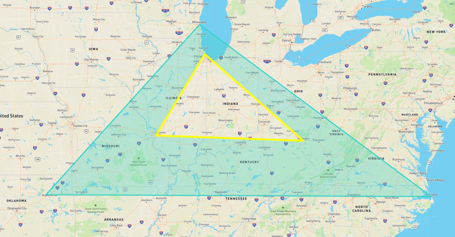
The JSON below is modified from the output above: it is grouped into a GeoJSON `FeatureCollection` in which each `Feature` has additional styling information (in the `properties` field) that can be used in visualization tools such as [geojson.io](http://geojson.io/):
```json theme={"theme":{"light":"catppuccin-mocha","dark":"catppuccin-mocha"}}
{
"type": "FeatureCollection",
"features": [
{
"properties": {
"fill-opacity": 0.3,
"stroke": "#30D5C8",
"stroke-width": 5,
"fill": "#30D5C8"
},
"geometry": {
"coordinates": [
[
[
-87.906471,
43.038902
],
[
-95.992775,
36.15398
],
[
-75.704722,
36.076944
],
[
-87.906471,
43.038902
]
],
[
[
-87.623177,
41.881832
],
[
-90.199402,
38.627003
],
[
-82.446732,
38.413651
],
[
-87.623177,
41.881832
]
]
],
"type": "Polygon"
},
"type": "Feature"
},
{
"properties": {
"stroke": "yellow",
"fill-opacity": 0.3,
"stroke-width": 9,
"fill": "yellow"
},
"geometry": {
"type": "LineString",
"coordinates": [
[
-87.623177,
41.881832
],
[
-90.199402,
38.627003
],
[
-82.446732,
38.413651
],
[
-87.623177,
41.881832
]
]
},
"type": "Feature"
}
]
}
```
Here is the geometry described above as shown on [geojson.io](http://geojson.io/):
 ## See also
* [GeoJSON RFC](https://www.rfc-editor.org/rfc/rfc7946.txt)
* Spatial Data Overview
* Spatial tutorial
* Spatial indexes
* Spatial and GIS Glossary of Terms
* Well known text
* Well known binary
* SRID 4326 - longitude and latitude
* Using GeoServer with CockroachDB
## See also
* [GeoJSON RFC](https://www.rfc-editor.org/rfc/rfc7946.txt)
* Spatial Data Overview
* Spatial tutorial
* Spatial indexes
* Spatial and GIS Glossary of Terms
* Well known text
* Well known binary
* SRID 4326 - longitude and latitude
* Using GeoServer with CockroachDB