> ## Documentation Index
> Fetch the complete documentation index at: https://cockroachlabs.mintlify.site/llms.txt
> Use this file to discover all available pages before exploring further.
# ST_Covers
export const InternalLink = ({version, path = "", children, ...props}) => {
let detectedVersion = version || "stable";
if (typeof window !== 'undefined' && !version) {
const match = window.location.pathname.match(/\/docs\/([^/]+)/);
if (match) {
detectedVersion = match[1];
}
}
const normalizedPath = path.startsWith("/") ? path.slice(1) : path;
return
{children}
;
};
Given two shapes *A* and *B*, predicate function `ST_Covers(A, B)` returns `true` if no point in *B* lies outside of shape *A*. Otherwise, it returns `false`.
In other words, shape *A* must completely cover every point in *B*.
This behavior is similar to `ST_Contains`, except that the criteria for `ST_Contains` are more exacting, and therefore some pairs of shapes will be accepted by this function that would be rejected by `ST_Contains`.
`ST_Covers` works on the following data types:
* `GEOMETRY`
* `GEOGRAPHY`
\`\` will attempt to use any available spatial index to speed up its operation. Use the prefixed variant `_` if you do not want any spatial indexes to be used.
This function is the inverse of `ST_CoveredBy`.
## Examples
The screenshots in these examples were generated using [geojson.io](http://geojson.io), but they are designed to showcase the shapes, not the map. Representing `GEOMETRY` data in GeoJSON can lead to unexpected results if using geometries with SRIDs other than 4326 (as shown below).
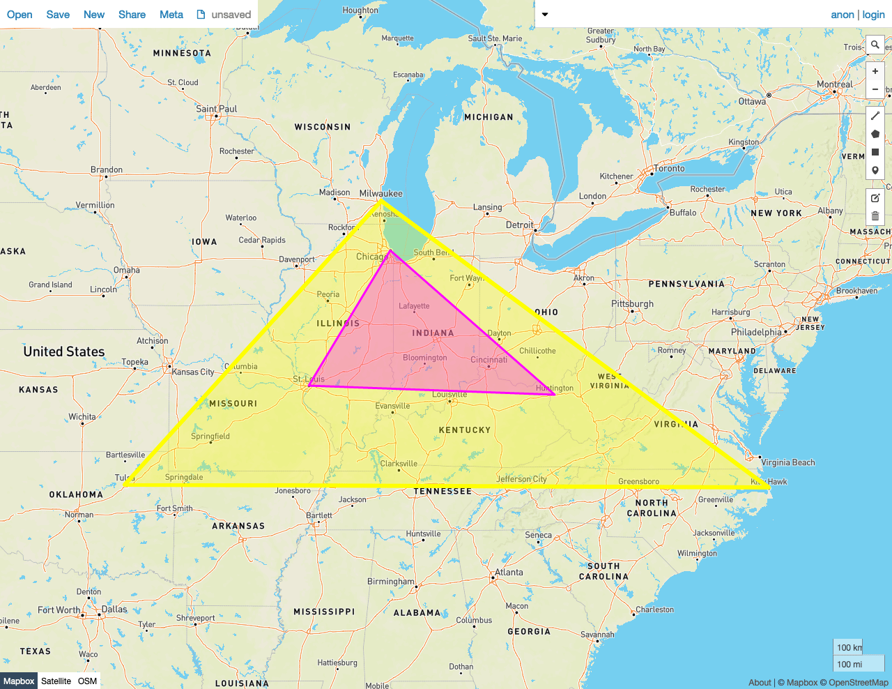
### True
In this example, \`\` returns `true` because:
* No Point in the smaller Polygon *B* lies outside of the larger Polygon *A*.
```sql theme={"theme":{"light":"catppuccin-mocha","dark":"catppuccin-mocha"}}
SELECT ST_Covers(st_geomfromtext('SRID=4326;POLYGON((-87.906471 43.038902, -95.992775 36.153980, -75.704722 36.076944, -87.906471 43.038902))'), st_geomfromtext('SRID=4326;POLYGON((-87.623177 41.881832, -90.199402 38.627003, -82.446732 38.413651, -87.623177 41.881832))'));
```
```
st_covers
---------------
true
(1 row)
```
 ### False
In this example, \`\` returns `false` because:
* Many Points in the smaller Polygon *B* lie outside of the larger Polygon *A*.
```sql theme={"theme":{"light":"catppuccin-mocha","dark":"catppuccin-mocha"}}
SELECT ST_Covers(st_geomfromtext('SRID=4326;POLYGON((-87.906471 43.038902, -95.992775 36.153980, -75.704722 36.076944, -87.906471 43.038902))'), st_geomfromtext('SRID=4326;POLYGON((-84.191605 39.758949, -75.165222 39.952583, -78.878738 42.880230, -84.191605 39.758949))'));
```
```
st_covers
---------------
false
(1 row)
```
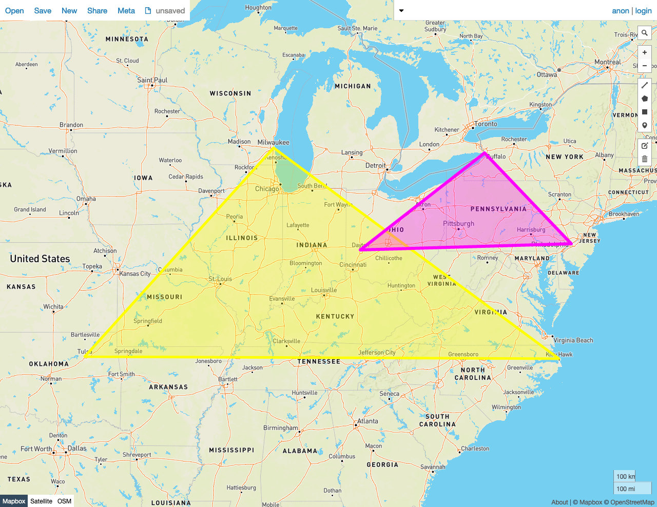
### False
In this example, \`\` returns `false` because:
* Many Points in the smaller Polygon *B* lie outside of the larger Polygon *A*.
```sql theme={"theme":{"light":"catppuccin-mocha","dark":"catppuccin-mocha"}}
SELECT ST_Covers(st_geomfromtext('SRID=4326;POLYGON((-87.906471 43.038902, -95.992775 36.153980, -75.704722 36.076944, -87.906471 43.038902))'), st_geomfromtext('SRID=4326;POLYGON((-84.191605 39.758949, -75.165222 39.952583, -78.878738 42.880230, -84.191605 39.758949))'));
```
```
st_covers
---------------
false
(1 row)
```
 ## See also
* Export Spatial Data
* Spatial tutorial
* Spatial and GIS Glossary of Terms
* Spatial indexes
* Spatial functions
- `ST_CoveredBy`
* `ST_Contains`
* `ST_Within`
* `ST_Intersects`
* `ST_CoveredBy`
* `ST_Disjoint`
* `ST_Equals`
* `ST_Overlaps`
* `ST_Touches`
* `ST_ConvexHull`
* `ST_Union`
* Migrate from Shapefiles
* Migrate from GeoJSON
* Migrate from GeoPackage
* Migrate from OpenStreetMap
* [Introducing Distributed Spatial Data in CockroachDB](https://www.cockroachlabs.com/blog/spatial-data/) (blog post)
* Using GeoServer with CockroachDB
## See also
* Export Spatial Data
* Spatial tutorial
* Spatial and GIS Glossary of Terms
* Spatial indexes
* Spatial functions
- `ST_CoveredBy`
* `ST_Contains`
* `ST_Within`
* `ST_Intersects`
* `ST_CoveredBy`
* `ST_Disjoint`
* `ST_Equals`
* `ST_Overlaps`
* `ST_Touches`
* `ST_ConvexHull`
* `ST_Union`
* Migrate from Shapefiles
* Migrate from GeoJSON
* Migrate from GeoPackage
* Migrate from OpenStreetMap
* [Introducing Distributed Spatial Data in CockroachDB](https://www.cockroachlabs.com/blog/spatial-data/) (blog post)
* Using GeoServer with CockroachDB